
Streams in Alaska are turning orange with iron and sulfuric acid. Scientists are trying to figure out why
BY ALEC LUHN
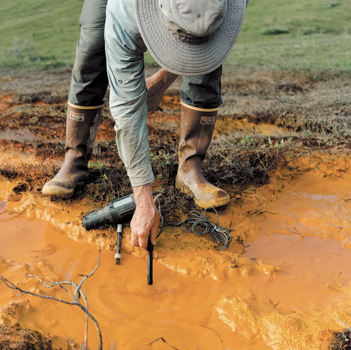
It was a cloudy July afternoon in Alaska's Kobuk Valley National Park, part of the biggest stretch of protected wilderness in the U.S. We were 95 kilometers (60 miles) from the nearest village and 400 kilometers from the road system. Nature doesn't get any more unspoiled. But the stream flowing past our feet looked polluted. The streambed was orange, as if the rocks had been stained with carrot juice. The surface glistened with a gasolinelike rainbow sheen. “This is bad stuff,” said Patrick Sullivan, an ecologist at the University of Alaska Anchorage.
Sullivan, a short, bearded man with a Glock pistol strapped to his chest for protection against Grizzly Bears, was looking at the screen of a sensor he had dipped into the water. He read measurements from the screen to Roman Dial, a biology and mathematics professor at Alaska Pacific University. Dissolved oxygen was extremely low, and the pH was 6.4, about 100 times more acidic than the somewhat alkaline river into which the stream was flowing. The electrical conductivity, an indicator of dissolved metals or minerals, was closer to that of industrial wastewater than the average mountain stream. “Don't drink this water,” Sullivan said.
Less than a dozen meters away the stream flowed into the Salmon River, a ribbon of swift channels and shimmering rapids that winds south from the snow-dimpled dun peaks of the Brooks Range. This is the last frontier in the state known as “the last frontier,” a 1,000-kilometer line of pyramidlike slopes that wall off the northern portion of Alaska from the gray, wind-raked Arctic Coast.
One of the most remote and undisturbed rivers in America, the Salmon has long been renowned for its unspoiled nature. When author John McPhee paddled the Salmon in 1975, it contained “the clearest, purest water I have ever seen flowing over rocks,” he wrote in Coming into the Country, an Alaska classic. A landmark 1980 conservation act designated it a wild and scenic river for what the government called “water of exceptional clarity,” deep, luminescent blue-green pools and “large runs of chum and pink salmon.”
Now, however, the Salmon is quite literally rusting. Tributary streams along one third of the 110-kilometer river are full of oxidized iron minerals and, in many cases, acid. “It was a famous, pristine river ecosystem,” Sullivan said, “and it feels like it's completely collapsing now.” The same thing is happening to rivers and streams throughout the Brooks Range—at least 75 of them in the past five to 10 years—and probably in Russia and Canada as well. This past summer a researcher spotted two orange streams while flying from British Columbia to the Northwest Territories. “Almost certainly it is happening in other parts of the Arctic,” said Timothy Lyons, a geochemist at the University of California, Riverside, who's been working with Dial and Sullivan.
Scientists who have studied these rusting rivers agree that the ultimate cause is climate change. Kobuk Valley National Park has warmed by 2.4 degrees Celsius (4.32 degrees Fahrenheit) since 2006 and could get another 10.2 degrees C hotter by 2100, a greater increase than projected for any other national park. The heat may already have begun to thaw 40 percent of the park's permafrost, the layer of earth just under the topsoil that normally remains frozen year-round. McPhee wanted to protect the Salmon River because humans had “not yet begun to change it.” Now, less than 50 years later, we have done just that. The last great wilderness in America, which by law is supposed to be “untrammeled by man,” is being trammeled from afar by our global emissions.
But how, exactly, permafrost thaw is turning these rivers orange has been a mystery. Solving it is crucial for understanding what the sweeping ecological impact could be and to help communities adapt, such as the eight Alaska Native villages that depend on rivers in the western Brooks Range for fish and drinking water. Some researchers think acid from minerals is leaching iron out of bedrock that has been exposed to water for the first time in millennia. Others think bacteria are mobilizing iron from the soil in thawing wetlands.
I had joined a group of scientists and wilderness buffs for a six-day trip down the Salmon to try to figure out which, if either, of these hypotheses explained the pollution in this once spotless waterway. We'd paddle downriver about 25 kilometers a day, passing from the treeless tundra near its headwaters to the boreal forest at its confluence with the broad, sluggish Kobuk River, then follow the Kobuk to the nearest village. Along the way we'd stop at as many tributaries as possible to take notes, collect vials of water and pick invertebrates off the rocks for the first comprehensive sampling of an entire rusting watershed. If the acid-rock hypothesis proved true, the fish downstream of certain mountains could be in lethal danger. If the bacteria hypothesis was right, the rusting could gradually smother streams almost anywhere there's permafrost—an area that includes about one fourth of the Northern Hemisphere.
To get close to the Salmon, two graduate students and I took a six-seater bush plane inland from the Arctic coast. The ice close to the Salmon had broken up in late spring, so any gravel bars on the river where a fat-tired bush plane might land were still under water. The best the pilot could do was to land on a long, flat gravel ridge in the mist-covered mountains north of the river. The rest of the group, who had been taking data in another watershed, was waiting there for our cargo of inflatable pack rafts, paddles, personal flotation devices, food and 52 water-sampling kits. We strapped the rafts, which folded down to the size of a gallon of milk, to the top of each pack for the hike to the river.
“This is the heaviest my backpack has ever been,” graduate student Maddy Zietlow said before we powered through 20 kilometers of windswept ridges, ankle-twisting tussocks and scratchy brush. We finally descended toward the luminescent braids of the Salmon to camp for the night as half a dozen white-coated Dall Sheep bounded away over a ridge.
The highest reaches of the Salmon still have clear water, but they're too rocky and shallow to float on, so the next morning we sloshed a few kilometers down the nascent river until we found a spot deep enough to launch our pack rafts. We stuffed the food and gear into oval storage tubes in the rafts and blew them up taut. During the first few kilometers of paddling, we had to lift our butts off the bottom of the rafts to keep from getting stuck every time the current scraped us over a ledge of rapids. We dodged aquamarine marble rocks the size of couch cushions.
When McPhee was here, he wrote that the river was so clear and full of fish that “looking over the side of the canoe is like staring down into a sky full of zeppelins.” These days, however, looking over the side is like staring down into a sky full of thick haze. An hour downstream from where we embarked, a large tributary called Kanaktok Creek was pumping in murky water over orange rocks, turning the Salmon green. The next incoming stream was so full of iron that the main stem ran half orange and half green. For the rest of the trip the river had the color and opacity of pea soup. “Most climate change is subtle,” said Forrest McCarthy, a former U.S. Antarctic Program field-safety coordinator, who was helping with water samples. “This is like, bam!” he continued, snapping his fingers.
The first investigators to document the rusting rivers were U.S. Geological Survey and National Park Service personnel studying how permafrost changes in the Brooks Range are affecting fish such as the Dolly Varden, a big, silvery green char with red spots that local villages prize above all others. In August 2018, when biologist Mike Carey flew by helicopter to retrieve a water sensor he had left in a clean stream east of the Salmon, he saw that the bottom was blanketed in orange slime. He couldn't find any fish or insects. “Biodiversity just crashed,” he recalled.
Carey thought the weird situation was a one-off until the following July, Alaska's hottest month on record. The Agashashok River, 96 kilometers west of the Salmon, turned from turquoise to orange-brown along part of its course. In the winter of 2019 the snowpack was abnormally high; that can insulate the ground, further encouraging permafrost thaw. Then came another hot summer and another snowy winter, and the rusting spread.
Dial and Sullivan, who had been studying the northward march of the tree line in the warming Brooks Range, were shocked by how fast streams there started transforming. On one 2020 expedition the water in a stream called Clear Creek was so acidic it curdled the powdered milk Zietlow used for her nightly tea. A loose network of interested scientists began to coalesce. For Dial, a kind of wilderness beatnik with a face of white stubble and a stream-of-consciousness manner of speaking, the expanding project was personal: he had been climbing mountains and floating rivers in the Brooks Range for more than 40 years. “It's fascinating from a scientific point of view, but from an emotional point of view, it's sad,” he said of the changes he's witnessing. “The alarming thing is how far our human reach is, in a big way.”
After about four hours on the water, we came to a wide bend where the river looked as if it were disappearing into a tunnel. The current had eaten deep into the softening shore, creating an overhang of earth at least 30 meters long. Muddy roots hung down like strands of a beaded curtain. Globules of watery dirt plopped into the river, and the air smelled like a mix of moldy towels and rotting vegetables—the unmistakable scent of thawing permafrost. “I don't remember that,” Sullivan said, frowning.
Permafrost ranges from isolated patches in Anchorage to a near-continuous sheet in the Brooks Range. If you set a fire and then dug down into the warmed area like gold miners did, under about a meter of seasonally thawed topsoil you'd find ground as hard as concrete and as many as 600 meters deep in places like Prudhoe Bay, much of which has been frozen since the last ice age. Within that layer is animal and plant matter holding twice as much carbon as the atmosphere does. When permafrost thaws, microbes begin to digest this matter and emit carbon dioxide and methane; that rotting-vegetable smell means the planet is cooking.
The ice contains other surprises as well. In Russia in 2016, anthrax reactivated by permafrost thaw led to the death of a 12-year-old boy. The softening earth could also unleash viruses, chemicals or mercury, a recent study warned—a Pandora's icebox of unexpected consequences. Still, the rusting of rivers blindsided the Alaska scientists. They suspected that the thaw was driving it, but they weren't sure how. Then David Cooper, an ecologist at Colorado State University, suggested what they now refer to as the “wetlands hypothesis”—the idea that microbes in the soil are producing not just methane but also soluble iron.